
Page 8 - DrivingTourBooklet2020
P. 8
Park sign. Turn left and drive until you see Lilly Park, the mouth of the other, of a similar kind, those men began to sing, and beet the tamboreens.
Bad River and the Lewis & Clark Center. The mouth of the Bad River, The women came forward highly deckerated in their way, with scalps and
although subject to 200 years of accretion and erosion, is still similar to trophies of war of their fathers, husbands, brothers or near connections
the time when Lewis and Clark were there. and (joined by five or six of the young men) proceeded to dance the War
4. Verendrye Monument. After you have been to viewing points 2 and 3 Dance...which they done with great cheerfulness until about 12 o’clock.”
above, drive to the top of the Verendrye Monument in the city of Fort By that time the captains needed to retire for the evening. They returned
Pierre. Here you can see to the keelboat, still anchored in the same place, accompanied by two
La Framboise Island, the chiefs who stayed with them all night.
curve of the Missouri
River, the mouth of the
Bad River, the plain to
the north between the
Bad River and Oahe
Dam, as well as the cities
of Pierre and Fort Pierre.
The Verendrye Monument looking southeast.
5. SD Cultural Heritage Center and Museum. Located at 900 Governors
Dr., Pierre, SD. Designated by the National Park Service as an official
site on the Lewis and Clark National Historic Trail. Exhibits show the
culture and history of the American Indians in this area, as well as the
formation and growth of South Dakota. A replica of a Lewis and Clark
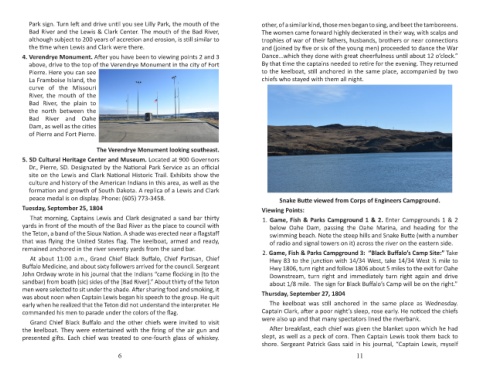
peace medal is on display. Phone: (605) 773-3458. Snake Butte viewed from Corps of Engineers Campground.
Tuesday, September 25, 1804 Viewing Points:
That morning, Captains Lewis and Clark designated a sand bar thirty 1. Game, Fish & Parks Campground 1 & 2. Enter Campgrounds 1 & 2
yards in front of the mouth of the Bad River as the place to council with below Oahe Dam, passing the Oahe Marina, and heading for the
the Teton, a band of the Sioux Nation. A shade was erected near a flagstaff swimming beach. Note the steep hills and Snake Butte (with a number
that was flying the United States flag. The keelboat, armed and ready, of radio and signal towers on it) across the river on the eastern side.
remained anchored in the river seventy yards from the sand bar. 2. Game, Fish & Parks Campground 3: “Black Buffalo’s Camp Site:” Take
At about 11:00 a.m., Grand Chief Black Buffalo, Chief Partisan, Chief Hwy 83 to the junction with 14/34 West, take 14/34 West ½ mile to
Buffalo Medicine, and about sixty followers arrived for the council. Sergeant Hwy 1806, turn right and follow 1806 about 5 miles to the exit for Oahe
John Ordway wrote in his journal that the Indians “came flocking in (to the Downstream, turn right and immediately turn right again and drive
sandbar) from boath (sic) sides of the [Bad River].” About thirty of the Teton about 1/8 mile. The sign for Black Buffalo’s Camp will be on the right.”
men were selected to sit under the shade. After sharing food and smoking, it
was about noon when Captain Lewis began his speech to the group. He quit Thursday, September 27, 1804
early when he realized that the Teton did not understand the interpreter. He The keelboat was still anchored in the same place as Wednesday.
commanded his men to parade under the colors of the flag. Captain Clark, after a poor night’s sleep, rose early. He noticed the chiefs
Grand Chief Black Buffalo and the other chiefs were invited to visit were also up and that many spectators lined the riverbank.
the keelboat. They were entertained with the firing of the air gun and After breakfast, each chief was given the blanket upon which he had
presented gifts. Each chief was treated to one-fourth glass of whiskey. slept, as well as a peck of corn. Then Captain Lewis took them back to
shore. Sergeant Patrick Gass said in his journal, “Captain Lewis, myself
6 11